VARANASI: The India Meteorological Department on Tuesday, October 27, warned of heavy to very heavy rain, thunderstorms, lightning and gusts of 40-50 kmph in Varanasi on Thursday, October 29. The district warning, issued at 12:30 IST, gives residents a short preparation window before a marked change from the dry weather recorded across Uttar Pradesh.
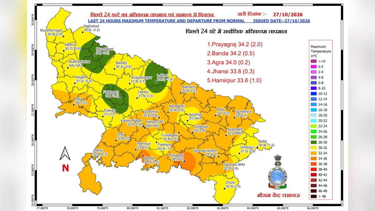
At the BHU observatory, the maximum temperature shown on IMD's October 27 observation map was 32.2 degrees Celsius, while Varanasi Airport recorded 33.4 degrees. These readings describe the preceding 24 hours. The rain forecast applies across Varanasi district, with the most substantial rainfall expected on Thursday rather than Tuesday.
When the rain is expected
The district rainfall forecast sets out a five-day progression. It keeps Tuesday dry, introduces very light to light rain at isolated places on Wednesday, and forecasts rain at most places on Thursday, with intensity reaching the very heavy category. Moderate rain at many places follows on Friday, before activity eases on Saturday. IMD assigns its very likely probability category to each of these five daily forecasts.
| Date | Varanasi district forecast |
|---|---|
| October 27 | Dry |
| October 28 | Very light to light rain at isolated places |
| October 29 | Rain at most places, moderate with very heavy spells |
| October 30 | Moderate rain at many places |
| October 31 | Very light to light rain at isolated places |
Each forecast day runs from 08:30 IST on the named date until 08:30 IST the following morning. Thursday's warning therefore covers the period from 08:30 IST on October 29 to 08:30 IST on October 30. Residents planning an overnight journey or outdoor work should read the dates using that validity period.
The separate impact-based warning explicitly includes Varanasi among districts facing heavy to very heavy rain on Thursday. Chandauli, Mirzapur, Jaunpur and Ghazipur are also named. The same day's thunderstorm and gust warning includes Varanasi, making wind and lightning relevant alongside the rainfall forecast.
What residents should prepare for
IMD identifies possible flooding in low-lying locations, waterlogged roads, reduced visibility and short local interruptions to water and electricity services during very heavy rain. These are potential impacts in the advisory. The bulletin does not report that such disruption has already occurred in Varanasi.
The department advises people to stay away from low-lying flood-prone areas, drains and seasonal watercourses. During thunderstorms, its guidance is to take shelter inside a secure building and avoid sheltering under trees. It also advises leaving water bodies and keeping away from objects that conduct electricity.
For journeys during heavy rain, the advisory calls for advance planning around likely delays and avoiding submerged roads, overflowing bridges and inundated underpasses. Outdoor workers and people travelling through exposed areas should check the latest warning before setting out, because a district forecast does not specify the exact hour rain will begin on an individual street.
The wider weather picture
In its state bulletin issued at 15:20 IST on October 27, IMD tracked very severe cyclonic storm Arnab over the west-central Bay of Bengal. It also reported an upper-air cyclonic circulation over southeast Uttar Pradesh and adjoining Bihar, alongside western disturbances affecting the wider region.
The state outlook anticipates little change in maximum temperatures for 24 hours, followed by a gradual fall of 7-9 degrees Celsius over the next three days and a subsequent recovery. That is a statewide outlook. Varanasi's day-by-day rainfall entries remain the more specific reference for local plans.
For earlier local context, see our reports on storm-related electricity disruption in Varanasi, silt clearance on the Ganga ghats and the end of September's East UP rain warning. Those reports cover earlier events; current planning should use the October 27 IMD bulletins.